Travel has been fairly quiet. Saturday, Day 11, I spent updating the blog, paying bill, doing laundry; the typical Saturday stuff.
Sunday, I packed up and headed to Mountain Home, ID. It was a comparatively short day. I only drove 270 miles. It did rain most of that time. I arrived at Mountain Home RV Park around 2 p.m. MT. The park was gorgeous with spacious concrete pads and lush green lawns. The dog park was even notable. The grass was so green, you could play golf on it. And the people were very friendly. I didn't want to disconnect the car, so I ate in, watched a little TV and went to bed.
Monday, Happy Labor Day, was a bit chilly in the morning. Yesterday's rain brought with it a cold front. I woke up to a 45 degree morning. Burrrr! Got the Bus ready for travel. I expected a light traffic day because of the holiday. I was right about that for most of the way.
My next stop was Pendleton, OR. The route took me through the rest of Idaho and into Oregon. There were some very steep hills. I stayed in the right lane and took my time. As I got closer to Pendleton, about 15 - 20 miles out, there are grade warnings along the road. I read one that had a list of cargo weights and maximum speeds for those weights. For my weight vehicle, the maximum speed was 43 mph. I'm thinking okay, I'll use the air brakes and low gear and be fine. I continue on my way. About two miles later, there is a sign similar to the first one reading, This is your final warning. Oh no, am I in for a time. Well, I did okay down this 6 -7 mile, 6% grade hill. The air brake worked great and I was doing fine. Then, well you've seen the road signs warning of a curve ahead? No joke, this one looked like a cinnamon bun. The road curved to the right in a sever circular direction. (Okay, I exaggerate a little.) So glad I had control of the Bus. That's not the end. As I'm coming out of that curve, there is another sign showing the road curving in the opposite direction. I was very happy to see a flat straight away at the bottom of the hill. Here is a YouTube video link of a trucker taking us for this ride. https://www.youtube.com/watch?v=eqBSBe0v0v8 Yep, that's pretty much what it felt like.
The campground was only two or three more miles. Once I got set up and the dogs taken care of, I googled the route. I discovered it's called Cabbage Hill and the curvy parts are called Deadman's Pass. I went from an elevation of 3,626 feet to 1,359 feet in the span of six miles. That is a 2267 foot descent. Yes, my ears were popping.
I got to the campground. Disconnect the car and the hitch would not store as it should. And when I went to move the car, the steering seemed unresponsive. Great. What am I going to do now? I drove the Bus to my site. I couldn't get it leveled. So I walked to the office and was assigned another site. Drove the Bus around the campground to the new site which thankfully was more level. After I set up and walked and fed the dogs, I made a phone call to our friend Bob and asked him about the hitch and the possible damage to the car. He wasn't familiar with my brand of hitch but thought that as long as my car tires were not scuffed or worn, I should be okay.
I moved the car to the site and it handled just fine. I took some soapy water and poured it on the hitch joint and it behaved properly. I must have been so sensitive from the drive down Cabbage Hill, that I wasn't thinking clearly. I kept my cool and didn't panic. All is right with the world.
I rested a while then it was time to get something to eat. My neighbors were enjoying the weather so I popped over to say "Hi". Lovely people. I said I was on my way to eat dinner, they invited me to join them. They were going to a Mexican place in town a bit later. I got out my chair and a glass of wine and enjoyed their company before we went to dinner.
Thank you, Dana, Gail, John and Kathy for the enjoyable meal and great conversation.
I'll give you a break from reading. My time in Pendleton was great. I have some fun stuff to share and some pictures. Hang in there, it will be posted soon.
Thanks for traveling with the Bootle Poodles.
Wednesday, September 7, 2016
Saturday, September 3, 2016
Days 9 & 10 Salt Lake City, Utah
Thanks for all the encouraging comments. Sometimes I think I'm crazy doing this. Maybe I am.
Thursday, 9/1, I drove into Salt Lake City (in the car). The first thing Terry and I would do in an unfamiliar city in which we were spending some time, would be to reserve seats on the Trolley Tour. That is exactly what I did. The Trolley picked me up at the rendezvous point at 9:30 a.m. We made several stops to pickup other guests. Our first tour stop was Temple Square. Our guide, Chris, gave us some background on the Mormon religion. We had a five minute photo stop and we where on to the next attraction. Here are a few shoots from the tour. Unfortunately, my phone did not charge last night and I ran out of power before the end of the tour.

The fountain activates on the hour and half hour. Our guide made sure we were there for the 10 a.m. viewing.
The gold Angel Moroni, atop the temple, is an angel who visited Joseph Smith numerous times beginning in 1823. According to Smith, the angel was the guardian of the golden plates, which Latter Day Saints believe were the source material of the Book of Mormon.
The tour took us passed the Utah State Houses. Yes, old and new right across the street from each other. We had an opportunity to see State Street. It is 17.3 miles long and said to be the longest straightest street in the US.
 We had the option to be dropped off back at Temple Square. I was the only one who took that option. The Tabernacle Choir was not singing, but I did enjoy an organ recital in one of the smaller tabernacles. The recital was half an hour consisting of seven pieces ending with Wagner's Ride of the Valkyries. It was awesome!
By the time I got out of there, it was time for some lunch. Our tour took us passed the City Creek Center. It is a shopping mall with a retractable roof and a re-creation of the south fork of historic City Creek. It is a very relaxing environment. My mile and a half walk back to the car took me right passed it. Looking around for an eatery, I stumbled upon Kneaders Cafe & Bakery. It is similar to Panera Bread but different. Waiting in line to order, a young man (who used to work for Kneaders) made meal suggestions and was quite helpful. I ended up with a chicken panini that was delicious.
After lunch, I completed my walk to the car and back to the Famcamp.
Friday, 9/2, I planned a trip to Antelope Island State Park. My friends Jim & Sherry told me about this park and recommended I check it out. Antelope Island is the largest island in Great Salt Lake. It is home to free-roaming herds of bison, bighorn sheep, mule deer and pronghorn antelope and many different types of birds.
This lake is the largest west of the Mississippi River. On average, it is 75 miles long by 28 miles wide, covering 1,700 square miles. Maximum depth is about 33 feet. Size and depth vary greatly with seasonal evaporation and precipitation.
There is no outlet for the water; so as the water evaporates, it leaves behind high concentrations of minerals.
 I was able to catch a photo of the south bound end of a north bound bison before I left the park.

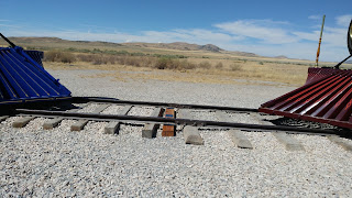 From Antelope SP, I drove to Golden Spike National Historic Site on Promontory Summit. About 95 miles northwest of the state park. Once I got off the interstate, the drive took me on the north side of the Great Salt Lake. Interesting. This site is where the Central Pacific (from the west) and Union Pacific (from the east) railroads met and connected railroad track.
There was disagreement on where the track was to meet. Congress, finally declared the meeting place to be Promontory Summit. On May 10, 1869, two locomotives - Central Pacific's Juniper and Union Pacific's No.119 - pulled up to the one-rail gap left in the track. After a golden spike was symbolically tapped, a final iron spike was driven to connect the railroads. Central Pacific laid 690 miles of track, Union Pacific 1,086. They had crossed 1,776 miles of desert, rivers, and mountains to bind together East and West.
That was it for my day. I made my way back to the Famcamp to take care of the dogs and eat some dinner. Oh, on the way back to the interstate, I got this shot of the evaporation on the Great Salt Lake. Look closely at the mountains. The white in front of them is evaporation.
Some of the information in this post was pulled directly from literature found at the places visited.
 |
| Mormon Tabernacle |
Thursday, 9/1, I drove into Salt Lake City (in the car). The first thing Terry and I would do in an unfamiliar city in which we were spending some time, would be to reserve seats on the Trolley Tour. That is exactly what I did. The Trolley picked me up at the rendezvous point at 9:30 a.m. We made several stops to pickup other guests. Our first tour stop was Temple Square. Our guide, Chris, gave us some background on the Mormon religion. We had a five minute photo stop and we where on to the next attraction. Here are a few shoots from the tour. Unfortunately, my phone did not charge last night and I ran out of power before the end of the tour.

 |
| Angel Moroni |
The gold Angel Moroni, atop the temple, is an angel who visited Joseph Smith numerous times beginning in 1823. According to Smith, the angel was the guardian of the golden plates, which Latter Day Saints believe were the source material of the Book of Mormon.
The tour took us passed the Utah State Houses. Yes, old and new right across the street from each other. We had an opportunity to see State Street. It is 17.3 miles long and said to be the longest straightest street in the US.

By the time I got out of there, it was time for some lunch. Our tour took us passed the City Creek Center. It is a shopping mall with a retractable roof and a re-creation of the south fork of historic City Creek. It is a very relaxing environment. My mile and a half walk back to the car took me right passed it. Looking around for an eatery, I stumbled upon Kneaders Cafe & Bakery. It is similar to Panera Bread but different. Waiting in line to order, a young man (who used to work for Kneaders) made meal suggestions and was quite helpful. I ended up with a chicken panini that was delicious.
After lunch, I completed my walk to the car and back to the Famcamp.
Friday, 9/2, I planned a trip to Antelope Island State Park. My friends Jim & Sherry told me about this park and recommended I check it out. Antelope Island is the largest island in Great Salt Lake. It is home to free-roaming herds of bison, bighorn sheep, mule deer and pronghorn antelope and many different types of birds.
 |
| Great Salt Lake from Visitor Center |
There is no outlet for the water; so as the water evaporates, it leaves behind high concentrations of minerals.
 I was able to catch a photo of the south bound end of a north bound bison before I left the park.
 From Antelope SP, I drove to Golden Spike National Historic Site on Promontory Summit. About 95 miles northwest of the state park. Once I got off the interstate, the drive took me on the north side of the Great Salt Lake. Interesting. This site is where the Central Pacific (from the west) and Union Pacific (from the east) railroads met and connected railroad track.
 There was disagreement on where the track was to meet. Congress, finally declared the meeting place to be Promontory Summit. On May 10, 1869, two locomotives - Central Pacific's Juniper and Union Pacific's No.119 - pulled up to the one-rail gap left in the track. After a golden spike was symbolically tapped, a final iron spike was driven to connect the railroads. Central Pacific laid 690 miles of track, Union Pacific 1,086. They had crossed 1,776 miles of desert, rivers, and mountains to bind together East and West.
That was it for my day. I made my way back to the Famcamp to take care of the dogs and eat some dinner. Oh, on the way back to the interstate, I got this shot of the evaporation on the Great Salt Lake. Look closely at the mountains. The white in front of them is evaporation.
 |
| Great Salt Lake From Promontory |
Thursday, September 1, 2016
Traveling Update
So, it's been a few days. Here's what's happened while I was off-line.
I left Donegal on Friday the 26th. Had an uneventful drive to the Indian Meadow Service Plaza on I80 in Ohio. I got there early enough and was able to park under a light. This is significant not only for the safety of the light but there is no parking directly under the light. I was able to put my passenger side slides out giving me more room inside. There was a drawback however; I was dry camping (no power, water, sewer). With no power and not wanting to run the generator all night to have air conditioning, it was a very hot night sleeping. Windows open and fans on, I made it. Donegal to the Service Plaza: 311 miles.
Saturday the 27th was a challenge. I drove I80 west through Indiana and Illinois. It rained most of the day. The good news (?), I had to take a detour south of Chicago that I think saved me three miles. Arrived at Geneseo Campground just east of the Mississippi River. The rain had stopped but the site was very muddy.
Service Plaza to Geneseo, IL: 322 miles
I set up the coach and took myself out to dinner. Sherry, the women in the camp store, suggested a family owned place called Sweet Peas. That's where I went. They had pulled pork which was tempting, but then I saw Pork and Mac. Interesting. I thought, 'I won't eat any veggies tonight, but that sounds good.' Guess what I ordered. That and a cup of Chicken Gumbo soup, I was all set. The soup was spicy and the Pork and Mac was delicious. I ordered a slice of chocolate layer cake to go and I was set for the night.
 Sunday the 28th, my drive took me west of Omaha, NE. I spent the night at Cabela's in LaVista, NE (in their parking lot). I called ahead to make sure overnight parking is allowed. Not only is it allowed, it's encouraged. From Geneseo, IL to LaVista, NE: 336 miles.
Well, it just so happens that a high school friend and his wife live about 10 miles east of LaVista. I contacted them several weeks ago to let them know I would be in town and; if they had time, I would like to see them. Paul and Astrid Bunning were happy I contacted them. They picked me up so I wouldn't have to disconnect the car. We went to Cantina Laredo Mexican Restaurant in Omaha for dinner. Our meals were delicious. During our time together, we caught up on what we had been doing for the last 47 years. The visit wasn't over. The Bunnings showed me around Old Town Omaha. The streets were fabulous. There were hanging flower baskets and the streets brick. The area was very clean and quite busy for a Sunday night. We ended up at Ted & Wally's for premium homemade ice cream. What a fabulous visit. Thank you Paul & Astrid.
Monday, Tuesday and Wednesday I drove, drove and drove. From LaVista to Ogallala, NE: 317 miles; Ogallala to Rawlins, WY: 318 miles; Rawlins to Hill AFB, Ogden, UT: 279 miles.
I'll stay at Hill AFB in Ogden, UT north of Salt Lake City for four nights. To date, I have driven 2,162 miles. This includes the 279 miles from home to my first stop in PA.
Here are some pictures of the scenery I shot during rest area breaks.
I spent the day, 9/1, in Salt Lake City. I will post that adventure in the next day or two. Thanks for traveling along.
I left Donegal on Friday the 26th. Had an uneventful drive to the Indian Meadow Service Plaza on I80 in Ohio. I got there early enough and was able to park under a light. This is significant not only for the safety of the light but there is no parking directly under the light. I was able to put my passenger side slides out giving me more room inside. There was a drawback however; I was dry camping (no power, water, sewer). With no power and not wanting to run the generator all night to have air conditioning, it was a very hot night sleeping. Windows open and fans on, I made it. Donegal to the Service Plaza: 311 miles.
Saturday the 27th was a challenge. I drove I80 west through Indiana and Illinois. It rained most of the day. The good news (?), I had to take a detour south of Chicago that I think saved me three miles. Arrived at Geneseo Campground just east of the Mississippi River. The rain had stopped but the site was very muddy.
Service Plaza to Geneseo, IL: 322 miles
I set up the coach and took myself out to dinner. Sherry, the women in the camp store, suggested a family owned place called Sweet Peas. That's where I went. They had pulled pork which was tempting, but then I saw Pork and Mac. Interesting. I thought, 'I won't eat any veggies tonight, but that sounds good.' Guess what I ordered. That and a cup of Chicken Gumbo soup, I was all set. The soup was spicy and the Pork and Mac was delicious. I ordered a slice of chocolate layer cake to go and I was set for the night.
 Sunday the 28th, my drive took me west of Omaha, NE. I spent the night at Cabela's in LaVista, NE (in their parking lot). I called ahead to make sure overnight parking is allowed. Not only is it allowed, it's encouraged. From Geneseo, IL to LaVista, NE: 336 miles.
Well, it just so happens that a high school friend and his wife live about 10 miles east of LaVista. I contacted them several weeks ago to let them know I would be in town and; if they had time, I would like to see them. Paul and Astrid Bunning were happy I contacted them. They picked me up so I wouldn't have to disconnect the car. We went to Cantina Laredo Mexican Restaurant in Omaha for dinner. Our meals were delicious. During our time together, we caught up on what we had been doing for the last 47 years. The visit wasn't over. The Bunnings showed me around Old Town Omaha. The streets were fabulous. There were hanging flower baskets and the streets brick. The area was very clean and quite busy for a Sunday night. We ended up at Ted & Wally's for premium homemade ice cream. What a fabulous visit. Thank you Paul & Astrid.
Monday, Tuesday and Wednesday I drove, drove and drove. From LaVista to Ogallala, NE: 317 miles; Ogallala to Rawlins, WY: 318 miles; Rawlins to Hill AFB, Ogden, UT: 279 miles.
I'll stay at Hill AFB in Ogden, UT north of Salt Lake City for four nights. To date, I have driven 2,162 miles. This includes the 279 miles from home to my first stop in PA.
Here are some pictures of the scenery I shot during rest area breaks.
 |
| West Wyoming |
 |
| Echo Canyon with a very long train. |
I spent the day, 9/1, in Salt Lake City. I will post that adventure in the next day or two. Thanks for traveling along.
Subscribe to:
Posts (Atom)